Kanatir fok Kanatir,
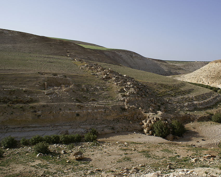
this is how Consul Wetzstein was explained that such a special contoured bridge crosses the Wadi esh Shellale. This is Arabic and means, arch over arch (unfortunately only the western river Bridge pier remained), the tunnel entrances east and west and a 12 m long plateau, which was the basis of the western abutment and a water settling basin.
During S. Mittmann’s excavation campaign on Khirbet ez Zeraqon, it was presumed that the ruins, or rather the foundations of the bridge, belong to a roman road. Already in 2002 and 2003, the team of the BAI determined by means of geophysical analyses and extensive surveys that both the investigated construction shafts and the bridge belonged rather to the Roman period than to the Early Bronze Age of the Khirbet ez Zeraqon. The project Qanat Fir'aun can basically only be owed to Prof. H. Fahlbusch from Luebeck, who after my first given references to Consul Wetzstein´s Book to him, also believed in an aqueduct. So he decided in 2003 to hand over this project proposal to the University of Darmstadt under the direction of the recognized hydrotechnical professor M. Döring.
In fact, after initial investigations, it became clear that the surveyed remains was really, at roman times an aqueduct bridge.
In several publications, the approx. 5 x 2.50 large brickwork arranged at a distance of 18-22m upstream were interpreted as an abutment of a operation bridge. In the current book about the aqueduct, the unfortunately incomprehensible thesis of an aqueduct bridge from construction phase I is represented. Neither by the much lower altitude of these ruins (which can be seen on those pictures), nor by on-or outgoing construction shafts, can this statement be proven.
In both structures, the river side wall was already broken in 2003, the stretcher and header construction with individual sections, clearly does not extrapolate to a pillar-like construction. The "operation bridge" specified by Böser/Otto at the first shot with a width of 44m clear spade was also represented by M.Döring in 2004. Böser/Otto, however, did not know the real structure on the eastern slope and constructed from the position of the heap of debris a virtual abutment lying parallel to the structure on the west side with the same altitude (therefore also 44m clear spade). However, according to my surveys from 2003 carried out for the BAI Wuppertal, it can be clearly shown that both structures have a clear spade of 40.78 m and the eastern side is 1.80 lower than the western one. Also, both structures are not aligned parallel to one another.
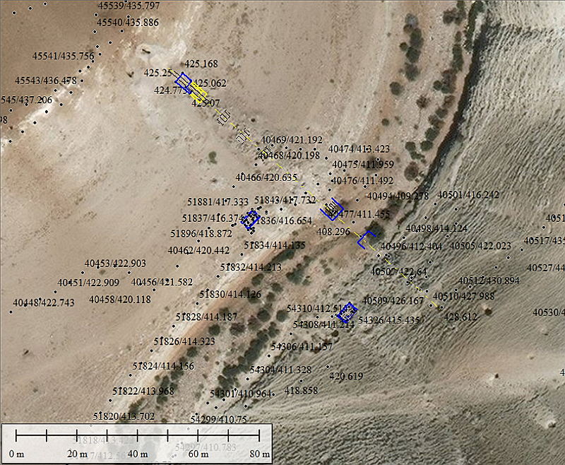
Based on the means of the own taken measurements of total 5000 points, in close proximity of the bridge and by evaluating the images, the following can be constrained for the actual aqueduct bridge:
The lower bridge level stood on 5.50m wide foundations (as the western river Bridge pier still proves), the bridge structure tapered out to about 3.0m wide in the second Level. The exact width of the specus is correspondingly smaller.
The clear span of the main arch can be determined to 10.5-11.0 m by regarding the remaining Bridge pier and the foundations of its opposit in situ.
The suggestion, made by S. Mittmann in 1999, that four to five arches in the lower level and nine in the upper one has existed once a time, can’t be proven.
After the analysis of the structure’s remains on the eastern slope of the Wadi, of the main arch and his clear span, results the height relations (height of the level - vault and low coverage - 1/2 clear span = remaining pier height). In addition to the western and eastern river Bridge piers, only two defined structures on the eastern slope (arch lower level and abutment second level) and on the western slope are clearly visible. (height of the first mentioned 414m asl and 418m asl of the last one mentioned, everything else is hidden in the rubble) At the western end of the bridge, the remaining stone plateau ends to the riverside direction with an arch of the upper row.
This stone plateau widened to 3.70m, carried a settling and transfer basin. It should also be noted that as a rule for structural reasons, the pier position of the upper row of arches were built directly above the pillars, symmetricaly to each other, or over the apex of the underlying arch. Thus, the forces could be derived directly into the arch (pressure on the apex) or just into the piers below. In addition, the same arch spans were important as construction principles. Thus, the very shortaged and expensive resource wood could be used effectively again for the formwork.
To this, the model created on the computer:
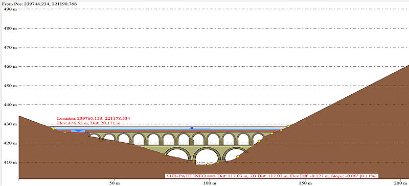
The total length, including the basin located at the western abutment, from mouth hole to the other mouth hole of the aqueduct tunnel , was 121m (at the height of the channel bottom the length was 117,03m). The height level of this channel at the western mouth hole is calculated to 426,53m asl.
The total height up to the channel above the wadi bed is 18.25m with the add of the height of the remaining specus and sidewalls of the channel from the channel bottom, is this a complete height of 19,75m (~ 1.50m including cover).
The flow width in the continuing tunnel section was in real ~ 90cm, as the sluice stones at the end of the transfer basin are no longer available is a definitive statement on this, no longer possible, but it was max. two big cubits, which corresponds to ~ 1.07m. According to those basic dimensions the mentioned settling basin was also carried out. Here it seems that special attention was paid to the perpendicularity towards the incoming and outgoing channel. This because that, on the southwest corner of the basin, the edge stone was cutted inside the basin, while at the northwest corner of the basin the opposit edge stone was cutted at the whole lenght to the adjacent stone . ( this one is stolen)
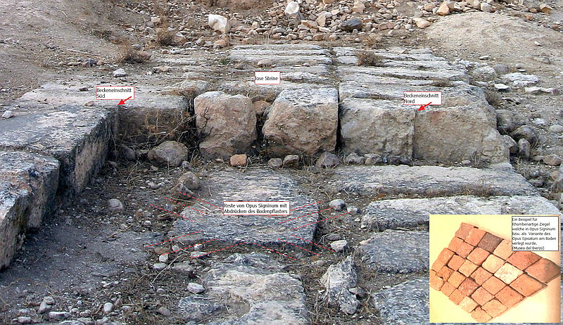
Also, many of the very regularly cut sandstone cuboids were exactly built after that cubit dimension (length often measured 107-108 cm with a width and height of 54.cm). In addition, there are also stone layers with foot and pace dimensions (2 1/2 feet).
The basin, which was 2.16 meters wide and presumably ~4.40 meters long at the western abutment, was sunken downwards by ~ 1.75 meters from the Channel bottom level. According to the measurements,it had a gradient of ~ 6.3% at the bottom against the flow direction of the aqueduct . At its lowest point, like in other discovered basins elsewhere, one or more cleaning openings certainly have had existed.
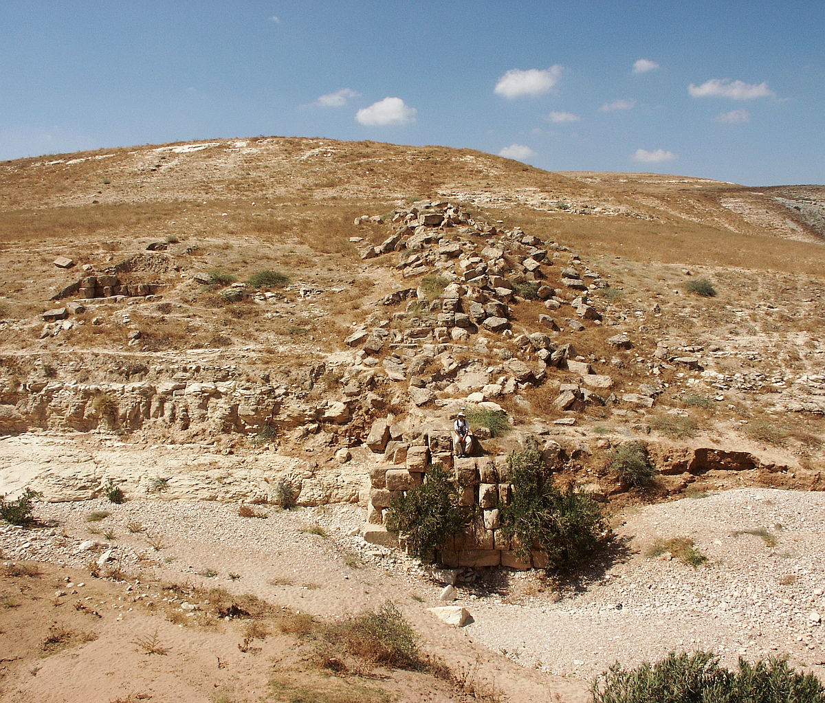 Zustand 2003 von Osten
 Zustand der Brücke und der Struktur oberstrom ( links) 2010
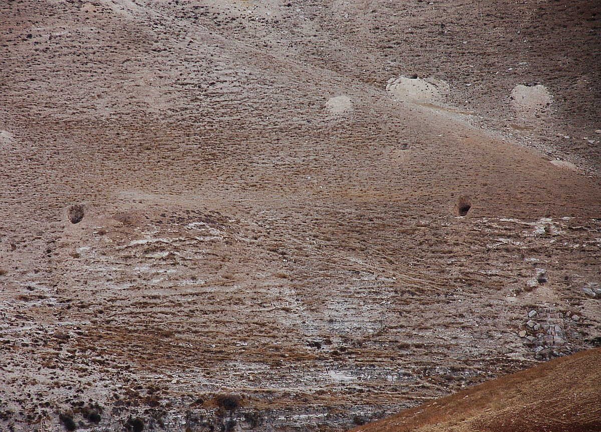 ankommende Bauschächte Ost und Brückenreste am rechten Bildrand
On the outlet side, the basin has a ca. 1.10 m x 0.55 m deep recess. Here was, like other basins in the literature, a regulation unit with one or more adjustable sluice gates. This recess is filled up with two fallen, or purposely outbroken stones. But those one are clearly not in situ there. Maybe there were also special cuttened Sluice Gate Blocks made from basalt, like at the end of the Gadara Aqueductbridge.
The fact that no one of the numerous researchers have recognized the basin as such, could be caused due the only rudimentary surrounding wall which still exists, and also because of the complete absence of the essential Opus Signinum, as a watertight plaster of such a basin. But looking closely at the overall situation and considering the details, a plausible solution can also be found for this. In the period self-observed by me between 2003-2010, construction material “in good condition”, with weights of several hundred kilograms per block, has "disappeared". In this case, as one can still recognize on some stone slabs of the basin-floor, a special form of the Opus Signinum, with inlayed cuttet stone of a rhomboid structure, has been installed. Either this served for the decoration, for the better cleaning, or for bridging the still visible bumps and joints of the basin floor. It seams clear that those 5-8 cm high stones could be substantially "easier and more efficient" stolen, than those mentioned above. But important is to pointed out, that this Stones left fine structure marks of waterproof mortar on the remaining stones.
Comparable mixed forms of the Opus Signinum also with stone forms as Opus Spicatum, or executed as Opus Sectile, can be found several times in the literature. (similarly, also ground area D in Abila). Likewise the technically identical and in principle similar execution of the basin is found, for example, at the Madradag aqueduct in Pergamon (compare also presentation of this basin by Garbrecht)
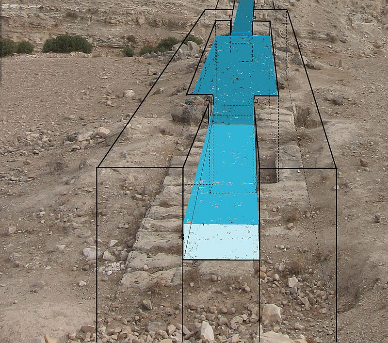 Rekonstruktion des Beckens von Westen
Individual surrounding stones with an hemispherical recesses suggest, that there may also have existed possibly a Nuria nearby the bridge, which raised the water of the Wadi esh Shellale to the height of the aqueduct when needed and supplemented this with it.
(Single-carousel: shellale-bruecke-plateau-ost-2003-k.jpg, mauerstruktur-west.jpg, shellale-bruecke8.jpg)
Such a waterwheel rotating on a large wooden beam is not unusual in the region and could possibly also explain the stone structures direct upstream of the bridge. I would be pleased to have a constructive discussion about this position. ;-)
Running along the western slope of the Wadi esh Shellale link to Wadi esh Shellale, the Qanat Fir'aun was led to the sources at Er-Rahub the "Cavea Roob" of Crusader times. here the link to the Cavea Roob / Ain Rahub