About 55m south of the dugged geological trench researched by B. Lucke,
in the Wadi Queilbeh the tunnel of the Qanat Fir'aun emerges for the first time at the daylight since the Wadi esh Shellale Bridge, in order to cross the wadi via a 80 m long and max. 6m high bridge.
B.Lucke could prove with his geological trench, that the Wadi bottom has been filled up , by several floodings or maybe also the collapsed aqueduct portion in this area, with sand and gravel, until 3,5m unto the Level of today.
Analogous to other aqueducts and similar widths, probably only one Arch with a clear span of 4.50m was present. The height of the Channel Bottom was 419.70 m asl.
After that, the aqueduct has distribute his water, still at the western side of the wadi area or latest in the directly adjacent section of the tunnel. A part of the water went to a side channel to Abila of the Decapolis, and the other one continues across many valleys to Gadara.
As geological investigations of the Yarmuok University showed, abutment remains of the bridge still exist in the wadi underground. Some hewn Blocks can be seen partly sunken in the soil of Wadi.
In addition, the southeastern mouth of the tunnel is accessible. As a result, both the location and height of the construction is proved. It can be assumed that at the northwest side, as well as in the Wadi esh Shellale, a basin was once arranged, which has functioned as a settling-basin and also as transfer-basin for the derivation to Abila. This Water was then led through the so-called "Upper Tunnel" to the city area of the decapolis metropolis. Another Aqueduct channel led to the urban area within a slightly deeper horizon, from the source, Ain Queilbeh.
From the beginning of the Hellenistic era to the important episcopal city in Byzantine times, the development of the city area always depended on these water supply systems. Thus, numerous maintenance measures of the systems prove their enormous importance.
The fact that Abila, one of the not explicitly mentioned main places of the region, of Ampeloessa was, described in the enumeration of Pliny within the decapolis, will be explained within the subpage - The Decapolis - .
Further evidence from carried out diggings suggests that the bridge was damaged during a strong earthquake in July 551 AD and the water flushed the valley. However, according to current geological discoveries by B. Lucke, this was not the decisive factor for the several soil changes in the Wadi Queilbeh including the adjoining slopes. For further interesting research results in this context, I refer to B. Lucke & C. Schmidt - Journal of Geomorphology Vol.61.
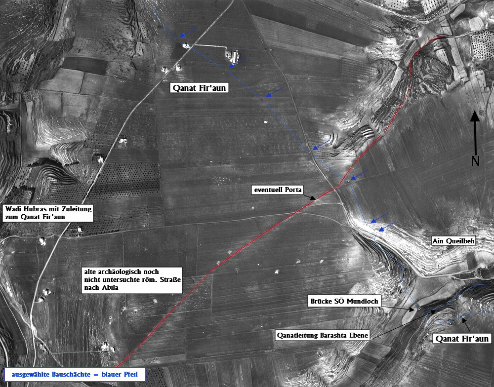
Once again, an old black and white image helps to analyze the further course (this time: provided by the Dept. of Geography / Jor.). Many of the construction shafts, which are still visible, could be verified on site, though many are completly closed, simply covered, or filled up with concrete. Maybe also some of them are undiscovered in the enclosed plantings of the olive groves.
Particularly noteworthy at this point, is the old road to Abila routed from the main road connection and still awaits further exploration.

Find out more about the course of the Qanat Fir'aun in the direction of Gadara here.