was a side channel to supply a nymphaeum and the highest areas of the city.
The about 4km long side line went to the ancient Adraha, with its highest part el Kerak and the nymphaeum lying on the slope side supplied with water from the Qanat Fir'aun.
The analysis was done here, as in the original Roman planning, in reverse order to determine necessary terrain heights and cross sections corresponding to the "requested" amounts of water on the nymphaeum can.
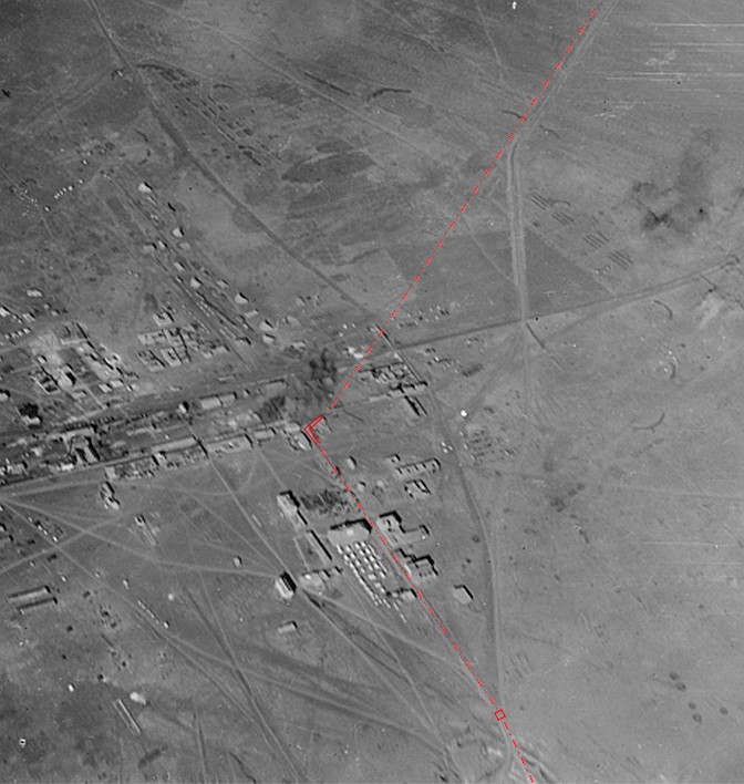 Linienführung der Druckleitungsabschnitte
Today, the Roman nymphaeum called "Hammam Ziknany" is reminiscent in its form and design, of the "Kalybe" (Qanawat, Shaba, Bosra), which is often found in Hauran. Possibly also existed two buildings as in Bosra opposite lying side by side. Today there are only 3 walls in parts, which still represent about half of the front facade, but here were at least still 4 discharges in the basalt masonry coming from the ceiling.

Detailed measurements are not known except for the measured elevations in m asl (above sea level). The height of the roof of the Nympheum, on which directly, or at the same height immediately next to it, was also the head basin / outlet basin of the pressure line, was about 523 m asl. The height of the floor at this nymphaeum / at the same time the ceiling height of the "mausoleum" mentioned distributor and the height of the pool edge of the large Siknany basin (~ 82x119m) is approximately 517m asl.
Assuming at least 8 tubes with Di = 6cm (comparable to Gadara and other nymphaea) and a gargoyle construction with Di = 2.0-2.5cm attached at the lower end of the vertical tube (so that there is no backwater, but also no outflow speed into the basin faster then > 3.5 m / s), roughly a volume of ~ 2.5-3l / s per tube would result, with the form to be estimated of 0.6 bar.
An incoming water volume of approx. Q ~ 20- 24 l / s (min 72 m³ / h) was therefore necessary.
A large supply of water on the roof / head basin is not likely to have taken place for static reasons. The water reservoir was safely distributed over a larger roof area. The upper edge of the water at the outlet pool was therefore not higher than 524m asl.
Unfortunately, neither J.G. Wetzstein still G. Schumacher a detailed description, or even the location of the "pharaoh tower" has given. Wetzstein seems to have it only described from an other one, and G. Schumacher, referring to Wetzstein's travelogue, could only guess, 50 years later, what ruins, on the north side of the wadi, were meant. The statement J.G. Wetzsteins, that the water had been transported on arches to the pharaoh tower, was very probably created only from the naming of this Aqueduct. The commonly used name at the time was simply Kanatir Far'un , the arches of the pharaoh. So also the interpretation of W.M. Thomson in his travelogue of 1886. Here he also confirms that the (auxiliary) direction arrived the city area from the northeast, but where the pharaoh tower stood, or at all a mention of it, we do not find in W. M. Thomson.
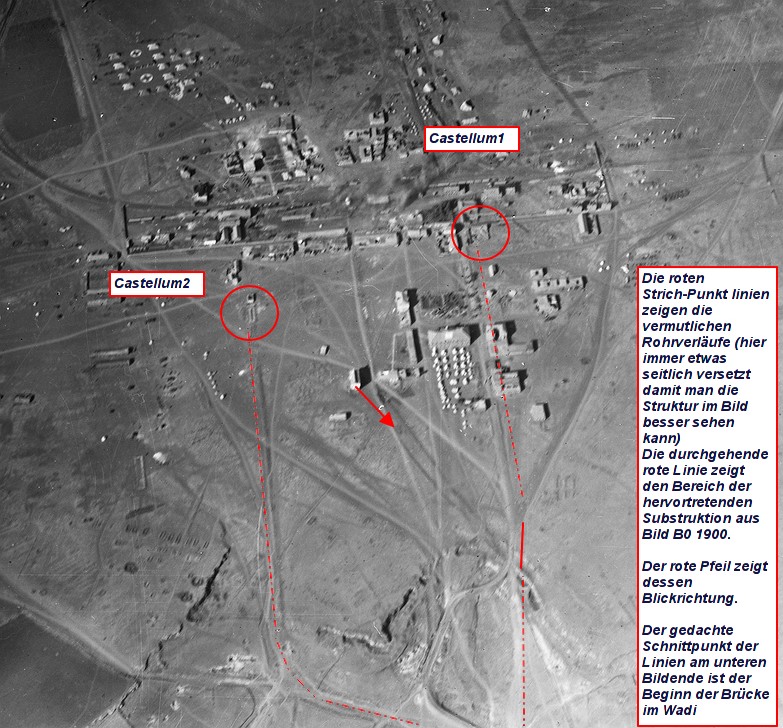
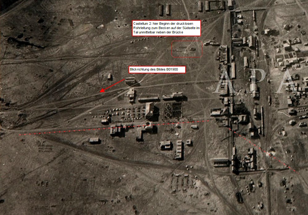
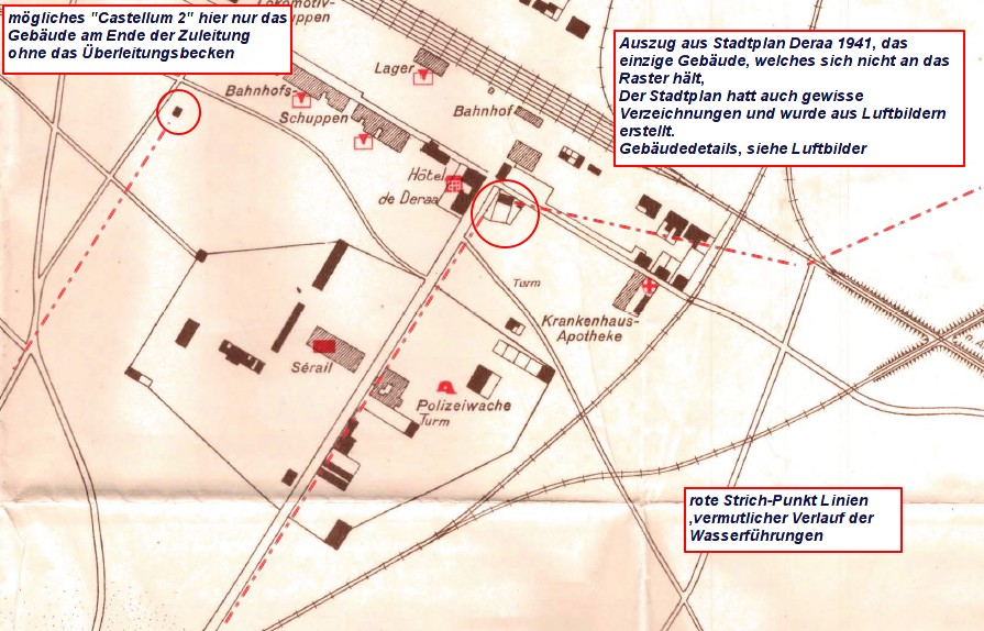
Old aerial photographs, a rare Dera'a city map, which I was able to buy together with the maps created by G. Schumacher, help us, in turn, supplemented by the digital elevation evaluation. Only a building or a ruin does not align itself with the grid in the newly created Railwayarea of Dera'a and corresponds to the necessary terrain heights. In addition, this building shows connections to the proven incoming and outgoing aqueductareas, through ground depressions and changes. In addition, G. Schumacher's card (thanks to the DPV for this) shows that the line ran exactly along the bridge.
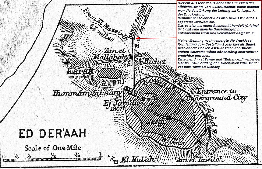 Kartendetail G.Schumacher
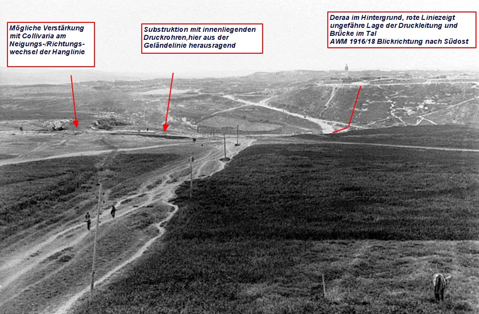
The pressure line through the Wadi Ez Zedi, from the so-called Pharaoh tower over the slope on the Wadi down to the bridge and then back up to the head basin on the roof of the Nympheum, is 1150 m long in 3D.
Because of the curvatures of the Suggested Course in addition and through the pipe generally creates a pressure loss, so it was a height difference between inlet and outlet basin of at least 3.5m necessary, in this case, however, the Q of a tube is around 10 l / s. The flow rate (velocity) was reduced to ~ 0.4 m / s or less. So it should have been a minimum of 2 pressurepipes at this section. In 2010, I explored the northern slope of El Kerak and on a broken vertical incision I was able to locate and document at least one of the pressure lines. However, it is not known, if there was another pressurepipe between the other one,which is still hidden in the Slope. The direction of this pressurepipe corresponded exactly to the extension of the eastern parapet of the Wadi ez Zedi bridge in the valley.
So far, the system can be very plausibly understood, in the following, the other part of the derivation (sidebranch) is examined to the pharao tower .
The verified main line of the Qanat Fir'aun traverses at one point the old Roman road Deraa - Bosra, from this point there was also an exactly straight line from an elevation 536m to the Castellum 1, the pharao tower J. G. Wetzsteins. Here is the terrain height at about 520m. The 3D length of this track is 2935m. (Note: a shortening of the route and division into free gauge and pressure range is unlikely due to the topography).
According to the previous paragraph, the inlet basin on the "pharaoh tower" was at least 527.5m asl (524m + 3.5m). With the length of 2935m and those assumed to have the same pipe dimensions, there is an estimated difference in height of almost 8.5m at almost the same flow rate to create the Q = 10l / s per pipe.
The hydr. System would look like this:
536m asl >>>>>>>>>>>>>>>>>>>>>>> 528m asl / 527,5m asl >>>>>>>>>>>>>>>>>>>> >>>> 524m asl
the lengths: 2935m >> Pharaoh tower >> 1150m >> Hammam Siknany
(Continuous 0.4m / s II Q ~ 10 l / s (with a tube of Di = 180mm and k = 5-7)
As a result of this extravagant investigation, it was feasible to supply the nymphaeum in the assumed form by means of two identical pressure pipelines. These were running completely close to the ground level and a single pressure tower at elevation 520 m asl and with a height of no more than 8.50 m over terrain.
After acquiring and the evaluating of special flyer images of the Australian War Memorial, as well as the city map of Dera'a (of the German General Staff of 1941), the "Pharao Tower" according to my virtual reconstruction has looked something like this.
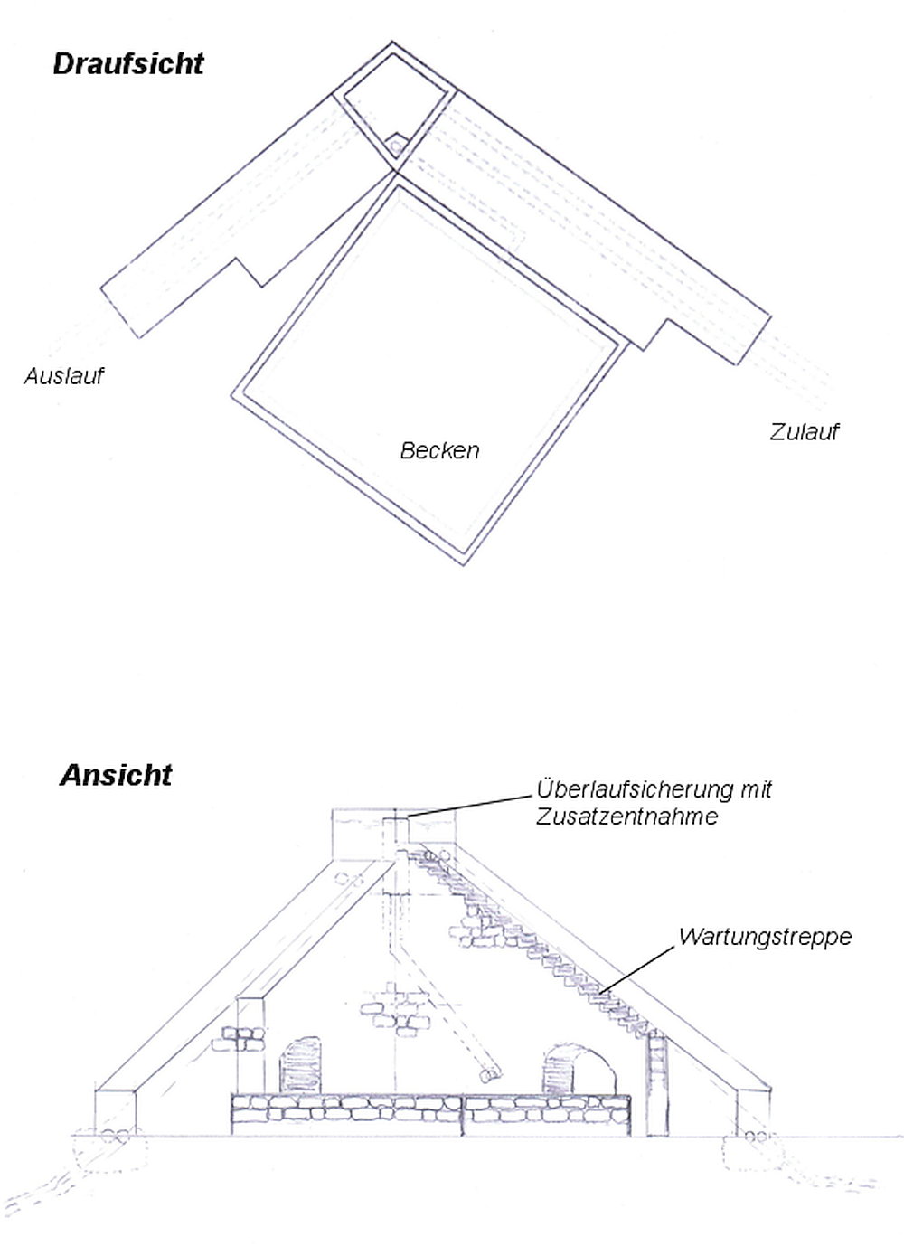 Rekonstruktion des sogenannten Pharaoturmes
 Ausschnitt DPV Karte B4
It is interesting that there were similar constructions from the same period also elsewhere, one of the aqueducts which provided today's Lyon had at Craponne such a building comparable to the Pharaoh tower.
 vergleichbarer Druckturm bei Craponne/France nach Gabut 1910
Here an other picture for comparison from 1918 of a siphon tower at Akko.
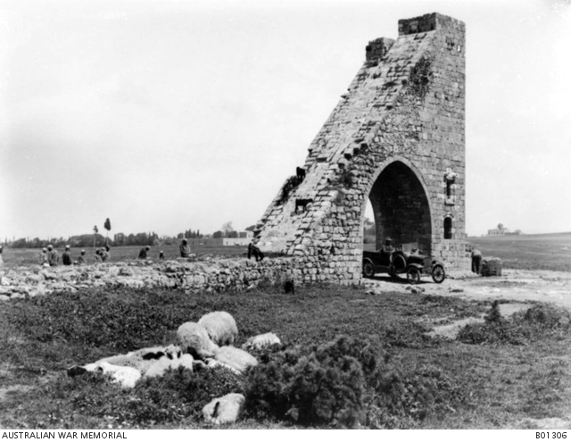
A as complicated by M.Döring shown and set off secondary line over 2.8 km to a quasi solitary on the hillside standing 25m high tower, is neither archaeologically detectable, nor was it mentioned in any description, or pictorial representation.
But the necessary volumes of the arches would have surpassed that of the main bridge, Jisr el Mesari , many times over, and are nowhere traceable.
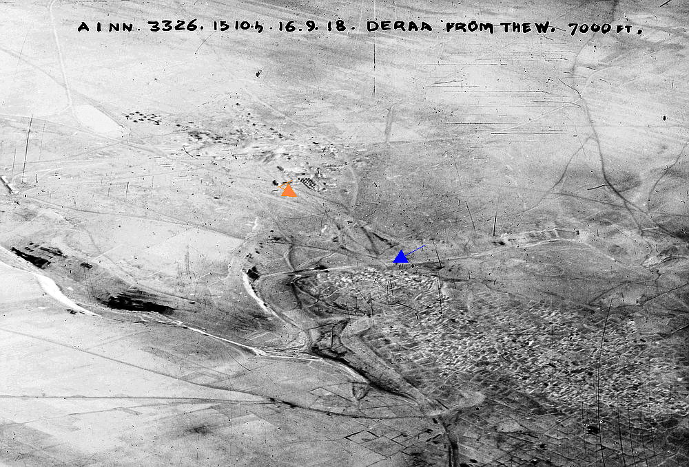
The following picture of the AWM shows the whole area of Deraa 1918 and those proves that such tremendous ruins have never exists. (blue arrow = bridge, orange arrow = viewing direction of the image B01300
The pipeline described by Wetzstein and sketched by G. Schumacher, which was the real pressure pipe to the hill of El Kerak or to the Nymphaeum, is technically incomprehensible in view of the location, high up on the parapet.
It can be assumed that the rebuilding of the Zedi Bridge (as also stated by G. Schumacher) either the pipe elements were reused or there was another pipe which crossed the wadi and the bridge. (See below)
For this purpose, it also seems important to pay attention to the wording in J.G.Wetzstein's description, he speaks on page 124 several times of "tubes" in the majority and the course within the 1.5m wide parapet of the bridge. Inexplicable remains, however, once again (as in the "Underground City") the size estimation in Consul Wetzstein descriptions because the today and certainly then bridge measures even at the extreme sill ends just 82m, the 300 paces (one pace are usually 2.5 feet, ie 75 to max. 82 cm), corresponding to around 230 m are also topographically incomprehensible.
Further information about the Zedi bridge in Dera'a can be obtained here under the category bridges.
From the maps of the DPV and individual documents, however, are also from north-northwest incoming aqueduct residues, which must also be included in the consideration.
After analysis, it can be assumed that a third pipe system, presumably later, was built. This led either a subset of the main aqueduct, via a completely different path, or the water of another reservoir to the Dera'a Area. A diversion basin to be recognized from the aerial photos, similar to the well-known diversion basin of Metz in France, also led in the course to the Wadi ez Zedi bridge in the valley.
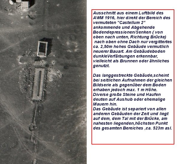
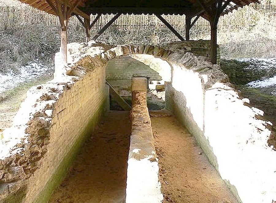
The non-complete sheathed clay pipe from G. Schumacher's description, which runs on the upper edge of the parapet, fulfills all static and height requirements for this 3rd pipe system.
In terms of height, however, only the basin directly behind the bridge, or "Birket", could be supplied with water. 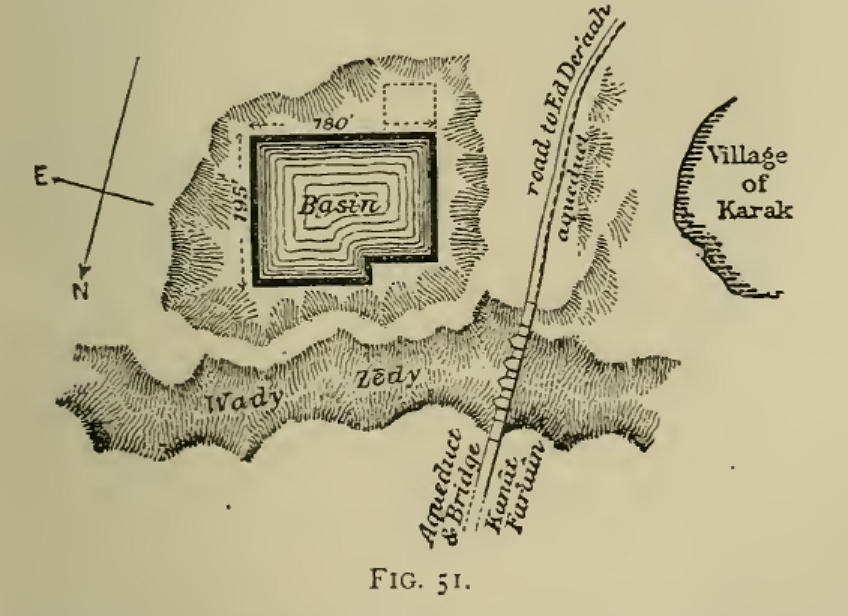
The water of the 2nd pressure pipe (described above) to the "Hammam Siknany", flowed as already described into the large basin before the Nymphäum, the further course of the Qanat Fir'aun you find therefore here.